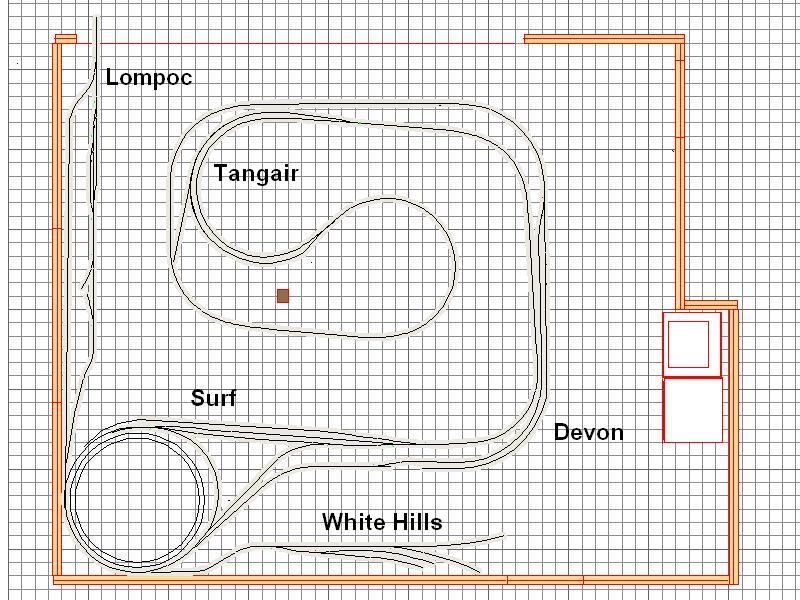
If you are wondering, I have been out in the layout room a couple of times but not too much progress to show for it. It seems that the list of projects on the layout is getting longer, not shorter! Currently, I am working on two major projects. The White Hills Branch track is in and working. Unfortunately to get to White Hills you need to go through Lompoc and the rail there has not even been laid. I am still working on final track arrangement in the small yard. although most of the ties have been glued down for the rest of the tracks. There will be a short section of street running in Lompoc. That is waiting for the substreet. I will talk more about Lompoc in another post.
Right now I am working on figuring out the track layout for the industrial area in Santa Barbara. I am really feeling the pinch for space. Because my layout runs along the thin wall in most locations there is not much space for scenery and industry. Even in the two area where there is flat "expanse" there is still not a lot of room. The entire space is only 20' x 20'. In HO scale that is 1740 feet. I am trying to model about 100 miles of the Coast Line and squeezing even the 4 scale miles into my two car garage has been a challenge.
The area for Santa Barbara is "L" shaped with each leg of the "L" about 8 feet long and 28" wide. The industrial area is across the main from the yard and the available space on one side is 8 feet long and varies from 10 to 25" wide and the other section is 42" long by about 10" wide. The distance from the real Santa Barbara Depot to the where single track starts at East Santa Barabara is just over a mile. Most of the industry was on the north (mountain) side of the main line. There was a track paralleling the main on that side, and off this track there were several spurs which served lumber yards, a concrete batch plant, a fruit packing plant, a building materials business, a moving and storage company, a grocery warehouse, numerous petroleum product wholesalers, an industrial laundry and a team track with a ramp for Pig flats (trailers on flat cars) behind the freight house.
It is impossible for me to fit all this in but I thought I would share some of my thoughts and processes on the way to putting at least a few on the layout. Most of the industries I mentioned are long gone and those that are still in existance are no longer rail served. In fact currently none of the spurs remain. The parallel track is still there for a short spur on the north side of the double track main.
Many of the buildings do still exist. I have taken many trips to the area and taken photos. I am only 7 miles away so it is easy for me but for some of you this is difficult if not improbable. I also use internet maps to see the area that you can use not only here but on your railroad. The two free services I use most are Google Maps (http://maps.google.com/) (along with Google Earth ) and Bing Maps (http://bing.com/maps). Google has a street view so you can virtually stand in the street and look at the buildings. Bing has a "birds eye" function that lets you explore the area from the air.
The other tool I use are Sanborn maps. These are fire insurance maps and show the buildings more reliably than the track layout but they are very helpful. Here is one of the Sanborns showing the Johnston Fruit Company and the Consolidated Rock facility. If you click on the maps or photos you can get a larger version.

You can see the yard and the main angling across the the right side of the map. To the right of the main you can see Puritan Ice which serviced the refrigerator car traffic in the Santa Barbara area and included an ice dock. I will mention that again later in this post. You can also see the parallel track and three of the spurs coming off that track and heading away from the yard. The top spur served Western Motor Transfer, a trucking company, but I will not be modeling that. The two lower spurs are serving industries.
If you note the spur serving Consolidated Rock Products actually comes off the same spur as that serving Johnston Fruit. The other spur services a water bottling plant which I will probably not model. Both spurs continue to the next map.

On this map you can see the US Highway 101. There use to be a viaduct to allow the tracks to cross underneath. This was removed about 1990 essentially eliminating rail service. On the lower portion of the map are additional Johnston Fruit Co. buildings and a Standard Oil facility. On the upper spur are a series of oil jobbers. This continues in the next map.
.

This map shows additional oil jobbers, McNall Building Supply, Coleman Building Supply, a grocery warehose and at the end of the curve, Union Oil Co. The curve originally continued along Gutierrez Street in Santa Barbara to the original station. this line was removed sometime after 1900 when the current alignment was established.
Here are some photos of the area as it is today with labels showing where the businesses were.
Here is an aerial photo showing the two spurs we have been considering in red and the main in blue.

Next is an aerial showing Johnston Fruit and Consolidated Rock.

Finally a photo with McNall Building Supply, Mission Industries (where the grocery warehouse was on the third Sanborn map), and Union Oil.

Now for some photos of the space on the layout.


.
As you can see in these two photos there is not a lot of space. I put a few cars in to show the approximate locations of the industries - reefers at Johnston, hoppers at ConRock, tank cars on the oil spur. My intention is to have Johnston Fruit Company be on flats against the wall to maximize the space. Standard Oil will be at the end of the Johnston Fruit spur as it was in real life.
Consolidated Rock will be on the next spur. I currently have just a flood loader but the plans are to have more of the batch plant.
The difficulty is squeezing in a few more of the petroleum distributors and McNall Building Supply. The track will curve at the end and Union Oil will fit there and the other spur at the end will be for Mission Industries.
I am in the process of moving the track around to see what will fit. There will be lots of kitbashing and scratch building to fill the space with narrow buildings that still reflect the flavor of the area.
Recently, I shared all of this with my local club. They made a suggestion for another section of the industrial area. On the first Sanborn map on the other side of the yard was Puritan Ice. I had put in an ice track but did so in such a way that there was no room for the icing platform or the plant - at least not on the proper side of the track. They suggested I move the track over a few inches. Even though the track was in and wired, I pulled it up and relaid it so now I can get the platform in and maybe some of the plant. An added benefit is that it lengthened the track so I can now get an extra car or two at the platform. In the photo you can see where the track was along the layout edge.

.
.
I am willing to move some track around but hope to get it close on the first installation. More time will be devoted to the individual industries here as they are completed. I will post as progress is made squeezing it all into the space.