Lompoc is located about 10 miles inland from the Pacific Ocean in the Santa Ynez Valley. The Spanish had established a mission in the valley where the town is now. The mission was destroyed by a massive earthquake (M 7.1) on December 21,1812. The mission was rebuilt at a new site further upstream. The town itself was begun as a temperance colony in 1874. By 1888 the temperance colony had vanished and the town of Lompoc was incorporated.
On June 1898 the Southern Pacific arrived in Lompoc on a ten mile spur from Surf. At the time the line south to Santa Barbara was still under construction so for a while trains from San Francisco terminated in Lompoc and passengers took stage coaches south to the rail head in Santa Barbara. This was short-lived. With the completion of the Coast Line December 31, 1900, the importance of Lompoc as a passenger terminal quickly faded.
The town continued to grow and thrive based on agriculture and the diatomaceous earth deposits in the hills south of town. The biggest specialty in agriculture was flower seeds. In 1909, Burpee seeds established Floradale Farms to test and produce seeds for cold weather agricultural and floral crops. The town has had a Flower Festival for years and also made headlines in by growing a huge American Flag in 2002 in honor of the 9/11 tragedy.

.
.
[A Quick Note: If you click on any of the photos you can see a larger version.]
.
.
In 1958,Vandenberg Air Force Base opened west of town as the nations first missle base. It is actively used today by both military and commercial operations as the nations western gateway to space. We will talk about Vandenberg AFB in a separate post.
.
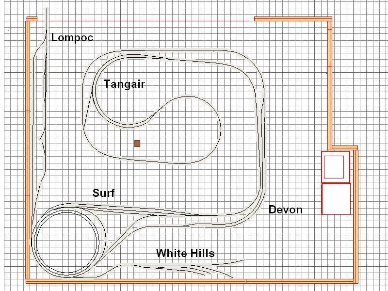
The railroad departs the main line at Surf, using a wye.

.
.
.
.
.
.
.
.
.
.
.
.
.
.
The line runs up the valley through fields of crops and flowers.


.
.
.
.
.
.
.
.
.
.
It enters town from the west through an avenue of palms,

.
crossing V Street. and running right down the middle of Laurel Street.


.
.
.
.
.
.
.
.
.
.
Much of the street running goes through residential areas including a school where the children often run to the fence to watch the train go by. I will be using selective compression (eliminate) on the tracks in this area to maximize the space available.


.
.
It crosses Lompoc's main north-south street (H Street) and passes the all important donut shop where crews frequently stop the train in the middle of the street while they run in and get some donuts and coffee.

At E Street, the line spreads into a small yard, coming back together at A Street.


.
.
.
.
.
.
.
.
The track proceeds east another 4 blocks to White Hills Junction which was covered in the earlier post.
My layout does not have ten miles of space so after we leave the main at Surf, the track go behind the helix and emerge on a 20 inch shelf above the west staging yard. My hope is to incorporate some small vignettes of flower fields as the track enters the shelf, a few palm trees in two rows, then do some street running to a small 3-track yard, before crossing onto the extension and reversing through the White Hills Junction switch and up the hill to the diatomaceous earth mine.
Here are some photos of the track that is in currently. I am still working on the turnouts and have not started the street running.

The wye at Surf showing the leg to Lompoc going through the wall and around the helix.

.
The tracks emerge from the helix and onto the shelf. This is where I plan to put the flower fields and the palm alley.

.
Here is a shot of the compressed Lompoc yard looking east. White Hills Jct is at the far end with the tracks to White Hills on the left. I had to flip the White Hills Branch in order to fit it onto the layout. The tracks climb steeply, as does the prototype, and winds around behind the helix to another shelf where the mine is located.

,
Street running area with styrene sub road and flextrack as a mock-up only.
For the street running I am planning on using the Easy Street system from Proto 87.
For the street running I am planning on using the Easy Street system from Proto 87.
http://www.proto87.com/easy-street--track-system.html
There were several rail-served businesses in Lompoc in the past. I hope to model a couple of these, as well as the Lompoc depot, a standard 22. We will discuss all these in a later post.
There were several rail-served businesses in Lompoc in the past. I hope to model a couple of these, as well as the Lompoc depot, a standard 22. We will discuss all these in a later post.