Tuesday, June 28, 2011

A Few More Car Card Boxes


I plan on using the car card and waybill method of moving cars from one location to another. When cars are spotted at an industry or in a yard, there is a need to store the corresponding car cards and waybills nearby to keep track of the cars. As I have mentioned before, I have already compromised my original druther of 36 inch aisles. As a result, I am continually looking for ways to minimize any intrusion into the aisle space. One of the best way I have seen is the use of car card boxes behind the fascia in the manner that Rick Fortin has on his layout.


I had built the boxes before and just needed to cut some additional holes in the fascia and mount the boxes behind the finished holes. I hope the following series of photos adequately demonstrates the process followed.


I also added a strip of plastic to hold car cards when they are being sorted. The strip is trim for holding FRP and is available at home improvement stores. It is visible in the last two photos above. I also am using some "J-bar" from Tap Plastics - http://www.tapplastics.com/shop/product.php?pid=155&


Both seem to work OK. Here is a photo of the clear J-bar just visible at the top of the fascia parallel to the track. Click on any of the photos for a larger view.


Measure Once, Cut Numerous Times!

Over two weeks ago I promised some updates and the time has flown past. I have decided to not bite off more than I can obviously chew and post several smaller items to get us caught up.

The first is an issue that I discovered almost a year ago. As you might recall, I spent some time at the Ventura County Fair last year assisting my friend Bob Lyon on his booth (see the post from August 20, 2010). At the fair I worked on several structures including the Standard Oil building for Carpinteria (see the post from August 23, 2010). There are several photos of the model building in that earlier post. If you look at the photos you will notice that the edge of the building is resting on the top of the fascia. I had modified the original kit so that it would fit into the space I thought I had. I obviously did not measure accurately as the building is not only a bit to large for the space but also makes it impossible to run a car down to the end of the Standard Oil spur track.

I looked at the model and decided I did not want to try to take it apart and shorten it up. That meant I needed to make the space I had bigger. One of the problems with cutting is that it usually makes items smaller. It is very difficult to make them bigger. In this case, I decided to go further against one of my initial druthers and narrow my aisle.

With the structure right on the aisle, I could envision it getting snagged as someone walked by so I needed to deal with that situation also. I had some Plexiglas so I planned on adding that to the outside of the model for protection.

I cut several short strips of masonite, the first was 1/4" like I use for the spline roadbed and the second was 1/8" like I use for the fascia. I placed those on the aisle side of the homasote of the Carpinteria section and then added the Plexiglas. This added 1/2" to a short 30" section of the layout infringing on that much aisle space. I guess I will have to work harder at reducing my girth so I can still fit in the aisle. Here is a top down photo showing the track with cars, the structure, the Homasote, the additional masonite, and the Plexiglas.


I then tested the spur track with one boxcar and it fit fine. Hoping to have learned my lesson about measuring twice and cutting once, I tested the track again with another boxcar and found the boxcar's door rail scrapped along the roof of the Standard Oil building. I decided this time to trim about 1/16" off the roof, which had a good overhang. After trimming the roof the wider boxcar slid by the building without contact. Lots of extra work but it fits fine now with some protection. Hopefully I will measure more closely in the future.

Here are a few photos of the finished retrofit.


Saturday, June 11, 2011

NMRA Daylight Division Meet

Progress is continuing on the Santa Barbara Subdivision and I will update the blog about that in a week or so. For now I will just say the helix is back together, the mainline, siding and wye tracks have all been permanently installed. I installed an autoreverser on the wye which works nicely. I finally made the decisions about the trackwork in the Santa Barbara industrial area so tracks are in and wired. I have also added some additional car card boxes for the Santa Barbara industries, but all this will be covered in the next installment.

For now, I would like to step back three weeks to May 21 when the Daylight Division of the Pacific Coast Region of the NMRA had their quarterly meet in Santa Barbara. I usually get called upon to help organize the meet here and this time was no exception. We met at Gary Siegel's house and everyone enjoyed seeing the progress Gary has made on his outdoor 1:32 layout. They also enjoyed his fabulous indoor HO L&N EK Division. It is my pleasure to operate on this superb railroad.
The meet included three clinics - modeling Eucalyptus trees, railroad traffic control systems [including a field trip to Gary's functioning CTC machine.] and how to track down shorts on you layout [an electrical discussion] -, a lunch, a business meeting, a white elephant auction, and lots of comraderie. After the meet several local layouts were open, including the SP Santa Barbara Subdivision. I had about 16 folks come by. Most of them had been to the Santa Barbara Subdivision before but the last time the Daylight Division came by there was only one level and only part of the thin walls up so they were impressed by the progress. To me it seems interminably slow, but I see it all the time.

Here is a photo taken by Brewster Bird during the Daylight Division Layout tour.

Check back in a week for the next update with details of the progress.

Thursday, April 28, 2011

Slow Progress

The progress on the SP Santa Barbara Subdivision has been down-right slow. In fact, I have actually taken a few steps backward.

The track in the outer helix was taken up temporarily. I ran a passenger train through and it was non-clearing so I looked at the track and it was too close to some of the supports. This will be easily fixed by centering the track. But it will wait for another project.

The main-line into Surf from the east had been put in temporarily to see how things ran and because I was procrastinating on installing a turnout for the siding. That turnout has been built but still needs to be installed. An additional turnout off the main at the east end of Surf accesses the wye. There is actually a "storage track" that runs parallel to the main and on the opposite side from the siding. It is from that track the actual legs of the wye begin. So besides the main/siding turnout, I need one turnout from the main, and one turnour from the storage track. Then because it is a wye I need to install an auto-reverser. All is ready, staged to be installed.

The street section of Lompoc is another big job that has been languishing. I laid down the base and now need to put in the street rail. Again, all is ready to be installed.

The industrial area across from the yard in Santa Barbara is still sitting. I keep looking at track arrangements, but so far have not made a decision so the tie strips are still in temporary positions. I complicated my decision recently by deciding to include the scale track.

The Santa Barbara scale track was located between the freight house and the spur to Johnston Fruit Co in the industrial area. It was on the track that parallels the double track main on the mountain side. Here is a wonderful photo that Charles Lange took of the scale and the scale house. You can see the Johnston Fruit Company in the background.


According to an October 1, 1966 Southern Pacific Company Circular 4 List of Agencies, Stations, Etc., the Santa Barbara scale track was 52.5 feet long, had a capacity of 125 tons, withs a Fairbanks scale. My problem is fitting it in. I have a space but the track is curved. I need at least 53 feet of straight track for the actual scale and should have some straight track leading up to both sides where the track has points to divert locomotives on separate track so as not to run across the beam of the scale. I may compromise here and have some minor curvature.

I also was looking at a USGS map of Santa Barbara and noticed two additional spur tracks. One led to the flour silos at the Weber's Bread bakery and the other led across a small bridge to another lemon packing house operated by Santa Barbara Lemon Co. Here is the map.


I do not have room for either of these on the layout but here is an interesting aerial view showing the still existing buildings. [Click on the image to make it larger.]


I did have the local club over a couple times. Once we just sat around and talked while installing Kadee couplers in some locomotives and freight cars. Some of the freights had the old horn-hook couplers but the locomotives and some of the other freight cars were using some of the Kadee copies. They do not seem to work as well, as the split or set in the wrong location and make coupling difficult to impossible. Here is a photo of that get together.


I had one of the club over on a Monday and we pulled wire to power the turnout motors for the first level. Second level power has already been pulled and we have four Tortoises installed. We also went out to lunch at a local eating establishment that holds some promise for the crews once I start real operations. Some of the club members came over the following evening and we drilled holes in the fascia for the turnout motor control switches, and wired up some of the switches.


Then this week they returned and they decided to be track inspectors. Using an NMRA track gauge and one of Micro-Mark inspection car (http://www.micromark.com/HO-Track-Inspection-Car-with-Metal-Wheels,8025.html ) they went along the track and put red tape everywhere the tracks needed work. I feel like the FRA just went through and issued slow orders for the layout. Here are some photos.


The local NMRA division is having a meet here in Santa Barbara on May 21 and the layout is on the tour after the meet, so I have lots of work to do between now and then, so you can expect another update in a few weeks.

Monday, March 14, 2011

Lompoc, Part I

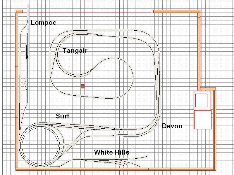
One of the three areas that still need to be completed on the railroad is Lompoc. There have been posts regarding the White Hills Junction Extension (August 19 and September 12, 2010) which is actually part of Lompoc, but we really have not talked about the town and the railroad related aspects that I find attractive and wish to attempt to model. While it is still far from complete, and not all the trackwork is down, I thought I would start so that you can understand my thoughts and watch the progress.

Lompoc is located about 10 miles inland from the Pacific Ocean in the Santa Ynez Valley. The Spanish had established a mission in the valley where the town is now. The mission was destroyed by a massive earthquake (M 7.1) on December 21,1812. The mission was rebuilt at a new site further upstream. The town itself was begun as a temperance colony in 1874. By 1888 the temperance colony had vanished and the town of Lompoc was incorporated.

On June 1898 the Southern Pacific arrived in Lompoc on a ten mile spur from Surf. At the time the line south to Santa Barbara was still under construction so for a while trains from San Francisco terminated in Lompoc and passengers took stage coaches south to the rail head in Santa Barbara. This was short-lived. With the completion of the Coast Line December 31, 1900, the importance of Lompoc as a passenger terminal quickly faded.
The town continued to grow and thrive based on agriculture and the diatomaceous earth deposits in the hills south of town. The biggest specialty in agriculture was flower seeds. In 1909, Burpee seeds established Floradale Farms to test and produce seeds for cold weather agricultural and floral crops. The town has had a Flower Festival for years and also made headlines in by growing a huge American Flag in 2002 in honor of the 9/11 tragedy.


.
.
[A Quick Note: If you click on any of the photos you can see a larger version.]
.
In 1958,Vandenberg Air Force Base opened west of town as the nations first missle base. It is actively used today by both military and commercial operations as the nations western gateway to space. We will talk about Vandenberg AFB in a separate post.
.
The railroad departs the main line at Surf, using a wye.
.
.
.
.
.
.
.
.
.
.
.
.
.
.
The line runs up the valley through fields of crops and flowers.


.
.
.
.
.
.
.
.
.
.
It enters town from the west through an avenue of palms,


.
crossing V Street. and running right down the middle of Laurel Street.


.
.
.
.
.
.
.
.
.
.
Much of the street running goes through residential areas including a school where the children often run to the fence to watch the train go by. I will be using selective compression (eliminate) on the tracks in this area to maximize the space available.


.
.
It crosses Lompoc's main north-south street (H Street) and passes the all important donut shop where crews frequently stop the train in the middle of the street while they run in and get some donuts and coffee.


At E Street, the line spreads into a small yard, coming back together at A Street.


.
.
.
.
.
.
.
.
The track proceeds east another 4 blocks to White Hills Junction which was covered in the earlier post.

My layout does not have ten miles of space so after we leave the main at Surf, the track go behind the helix and emerge on a 20 inch shelf above the west staging yard. My hope is to incorporate some small vignettes of flower fields as the track enters the shelf, a few palm trees in two rows, then do some street running to a small 3-track yard, before crossing onto the extension and reversing through the White Hills Junction switch and up the hill to the diatomaceous earth mine.

Here are some photos of the track that is in currently. I am still working on the turnouts and have not started the street running.


The wye at Surf showing the leg to Lompoc going through the wall and around the helix.


.
The tracks emerge from the helix and onto the shelf. This is where I plan to put the flower fields and the palm alley.


.
Here is a shot of the compressed Lompoc yard looking east. White Hills Jct is at the far end with the tracks to White Hills on the left. I had to flip the White Hills Branch in order to fit it onto the layout. The tracks climb steeply, as does the prototype, and winds around behind the helix to another shelf where the mine is located.


,
Street running area with styrene sub road and flextrack as a mock-up only.

For the street running I am planning on using the Easy Street system from Proto 87.
http://www.proto87.com/easy-street--track-system.html

There were several rail-served businesses in Lompoc in the past. I hope to model a couple of these, as well as the Lompoc depot, a standard 22. We will discuss all these in a later post.

Monday, January 24, 2011

Squeezing It All In

Except for the posting of the Santa Claus train for the holiday, I have not posted since September. Where has the time gone. In September I went with my wife to Rocky Ops in Colorado and operated on three nice layouts. Then we headed west over the Rockies to Utah and the Great Basin Getaway for four more wonderful operating sessions. From Salt Lake City we headed west again to Sacramento to visit friends and attend the Southern Pacific Historical & Technical Society Convention. In October I taught a one day class at Cal Poly SLO on railroads of the central California Coast. In November we headed for Portland for Thanksgiving with my son. Even got a few train visits in while we were there. That is in addition to all the normal activities around here.

If you are wondering, I have been out in the layout room a couple of times but not too much progress to show for it. It seems that the list of projects on the layout is getting longer, not shorter! Currently, I am working on two major projects. The White Hills Branch track is in and working. Unfortunately to get to White Hills you need to go through Lompoc and the rail there has not even been laid. I am still working on final track arrangement in the small yard. although most of the ties have been glued down for the rest of the tracks. There will be a short section of street running in Lompoc. That is waiting for the substreet. I will talk more about Lompoc in another post.

Right now I am working on figuring out the track layout for the industrial area in Santa Barbara. I am really feeling the pinch for space. Because my layout runs along the thin wall in most locations there is not much space for scenery and industry. Even in the two area where there is flat "expanse" there is still not a lot of room. The entire space is only 20' x 20'. In HO scale that is 1740 feet. I am trying to model about 100 miles of the Coast Line and squeezing even the 4 scale miles into my two car garage has been a challenge.

The area for Santa Barbara is "L" shaped with each leg of the "L" about 8 feet long and 28" wide. The industrial area is across the main from the yard and the available space on one side is 8 feet long and varies from 10 to 25" wide and the other section is 42" long by about 10" wide. The distance from the real Santa Barbara Depot to the where single track starts at East Santa Barabara is just over a mile. Most of the industry was on the north (mountain) side of the main line. There was a track paralleling the main on that side, and off this track there were several spurs which served lumber yards, a concrete batch plant, a fruit packing plant, a building materials business, a moving and storage company, a grocery warehouse, numerous petroleum product wholesalers, an industrial laundry and a team track with a ramp for Pig flats (trailers on flat cars) behind the freight house.

It is impossible for me to fit all this in but I thought I would share some of my thoughts and processes on the way to putting at least a few on the layout. Most of the industries I mentioned are long gone and those that are still in existance are no longer rail served. In fact currently none of the spurs remain. The parallel track is still there for a short spur on the north side of the double track main.

Many of the buildings do still exist. I have taken many trips to the area and taken photos. I am only 7 miles away so it is easy for me but for some of you this is difficult if not improbable. I also use internet maps to see the area that you can use not only here but on your railroad. The two free services I use most are Google Maps (http://maps.google.com/) (along with Google Earth ) and Bing Maps (http://bing.com/maps). Google has a street view so you can virtually stand in the street and look at the buildings. Bing has a "birds eye" function that lets you explore the area from the air.

The other tool I use are Sanborn maps. These are fire insurance maps and show the buildings more reliably than the track layout but they are very helpful. Here is one of the Sanborns showing the Johnston Fruit Company and the Consolidated Rock facility. If you click on the maps or photos you can get a larger version.


You can see the yard and the main angling across the the right side of the map. To the right of the main you can see Puritan Ice which serviced the refrigerator car traffic in the Santa Barbara area and included an ice dock. I will mention that again later in this post. You can also see the parallel track and three of the spurs coming off that track and heading away from the yard. The top spur served Western Motor Transfer, a trucking company, but I will not be modeling that. The two lower spurs are serving industries.

If you note the spur serving Consolidated Rock Products actually comes off the same spur as that serving Johnston Fruit. The other spur services a water bottling plant which I will probably not model. Both spurs continue to the next map.


On this map you can see the US Highway 101. There use to be a viaduct to allow the tracks to cross underneath. This was removed about 1990 essentially eliminating rail service. On the lower portion of the map are additional Johnston Fruit Co. buildings and a Standard Oil facility. On the upper spur are a series of oil jobbers. This continues in the next map.
.


This map shows additional oil jobbers, McNall Building Supply, Coleman Building Supply, a grocery warehose and at the end of the curve, Union Oil Co. The curve originally continued along Gutierrez Street in Santa Barbara to the original station. this line was removed sometime after 1900 when the current alignment was established.

Here are some photos of the area as it is today with labels showing where the businesses were.

Here is an aerial photo showing the two spurs we have been considering in red and the main in blue.


Next is an aerial showing Johnston Fruit and Consolidated Rock.
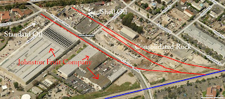


Finally a photo with McNall Building Supply, Mission Industries (where the grocery warehouse was on the third Sanborn map), and Union Oil.


Now for some photos of the space on the layout.


.

As you can see in these two photos there is not a lot of space. I put a few cars in to show the approximate locations of the industries - reefers at Johnston, hoppers at ConRock, tank cars on the oil spur. My intention is to have Johnston Fruit Company be on flats against the wall to maximize the space. Standard Oil will be at the end of the Johnston Fruit spur as it was in real life.

Consolidated Rock will be on the next spur. I currently have just a flood loader but the plans are to have more of the batch plant.

The difficulty is squeezing in a few more of the petroleum distributors and McNall Building Supply. The track will curve at the end and Union Oil will fit there and the other spur at the end will be for Mission Industries.

I am in the process of moving the track around to see what will fit. There will be lots of kitbashing and scratch building to fill the space with narrow buildings that still reflect the flavor of the area.

Recently, I shared all of this with my local club. They made a suggestion for another section of the industrial area. On the first Sanborn map on the other side of the yard was Puritan Ice. I had put in an ice track but did so in such a way that there was no room for the icing platform or the plant - at least not on the proper side of the track. They suggested I move the track over a few inches. Even though the track was in and wired, I pulled it up and relaid it so now I can get the platform in and maybe some of the plant. An added benefit is that it lengthened the track so I can now get an extra car or two at the platform. In the photo you can see where the track was along the layout edge.


.
.
I am willing to move some track around but hope to get it close on the first installation. More time will be devoted to the individual industries here as they are completed. I will post as progress is made squeezing it all into the space.